- Fichier original HD - JPG (6192x4128px)
- Haute définition - JPG - JPG (4000x2666px)
- Haute définition © intégré - JPG - JPG (4000x2666px)
- Moyenne définition © intégré - JPG - JPG (1920x1280px)
- Moyenne définition - JPG - JPG (1920x1280px)
- Basse définition - JPG - JPG (1200x800px)
- Basse définition © intégré - JPG - JPG (1200x800px)
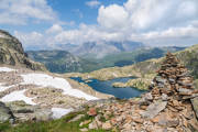
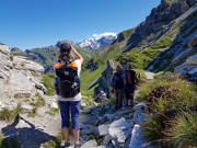
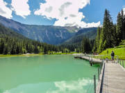
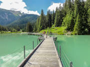
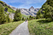
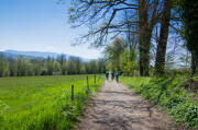
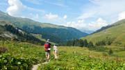
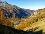
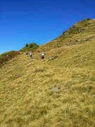
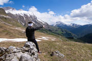
ASMB-SB012016
Randonnée au lac Cornu sur le Tour des Lacs dans le massif des Aiguilles Rouges à Chamonix avec vue sur la chaîne des Fiz
©SavoieMontBlanc-Bijasson
- Fichier original HD - JPG (4032x3024px)
- Haute définition - JPG - JPG (4000x3000px)
- Haute définition © intégré - JPG - JPG (4000x3000px)
- Moyenne définition © intégré - JPG - JPG (1920x1440px)
- Moyenne définition - JPG - JPG (1920x1440px)
- Basse définition - JPG - JPG (1200x900px)
- Basse définition © intégré - JPG - JPG (1200x900px)
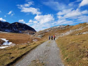
ASMB-VC011974
Randonnée sur le belvédère de la Grande Berge au-dessus de Roselend
©SavoieMontBlanc-Cervellin
- Fichier original HD - JPG (4032x3024px)
- Haute définition - JPG - JPG (4000x3000px)
- Haute définition © intégré - JPG - JPG (4000x3000px)
- Moyenne définition © intégré - JPG - JPG (1920x1440px)
- Moyenne définition - JPG - JPG (1920x1440px)
- Basse définition - JPG - JPG (1200x900px)
- Basse définition © intégré - JPG - JPG (1200x900px)
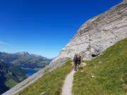
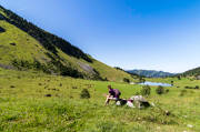
ASMB-VC011992
Randonneurs sur le tour du Rocher du Vent avec vue sur le lac de Roselend
©SavoieMontBlanc-Cervellin
- Fichier original HD - JPG (4032x3024px)
- Haute définition - JPG - JPG (4000x3000px)
- Haute définition © intégré - JPG - JPG (4000x3000px)
- Moyenne définition © intégré - JPG - JPG (1920x1440px)
- Moyenne définition - JPG - JPG (1920x1440px)
- Basse définition - JPG - JPG (1200x900px)
- Basse définition © intégré - JPG - JPG (1200x900px)
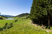
ASMB-VC011993
Vue sur le tour du Rocher du Vent
©SavoieMontBlanc-Cervellin
- Fichier original HD - JPG (4032x3024px)
- Haute définition - JPG - JPG (4000x3000px)
- Haute définition © intégré - JPG - JPG (4000x3000px)
- Moyenne définition © intégré - JPG - JPG (1920x1440px)
- Moyenne définition - JPG - JPG (1920x1440px)
- Basse définition - JPG - JPG (1200x900px)
- Basse définition © intégré - JPG - JPG (1200x900px)
ASMB-VC011995
Randonneurs sur le tour du Rocher du Vent avec vue sur le massif du Mont-Blanc
©SavoieMontBlanc-Cervellin
- Fichier original HD - JPG (7008x1952px)
- Haute définition - JPG - JPG (4000x1114px)
- Haute définition © intégré - JPG - JPG (4000x1114px)
- Moyenne définition © intégré - JPG - JPG (1920x534px)
- Moyenne définition - JPG - JPG (1920x534px)
- Basse définition - JPG - JPG (1200x334px)
- Basse définition © intégré - JPG - JPG (1200x334px)
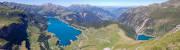
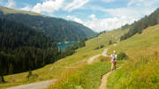
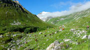
ASMB-VC011996
Panorama sur les lacs de Roselend et de la Gittaz sur le tour du Rocher du Vent
©SavoieMontBlanc-Cervellin
- Fichier original HD - JPG (4032x3024px)
- Haute définition - JPG - JPG (4000x3000px)
- Haute définition © intégré - JPG - JPG (4000x3000px)
- Moyenne définition © intégré - JPG - JPG (1920x1440px)
- Moyenne définition - JPG - JPG (1920x1440px)
- Basse définition - JPG - JPG (1200x900px)
- Basse définition © intégré - JPG - JPG (1200x900px)

ASMB-VC011997
Randonneurs sur le tour du Rocher du Vent avec vue sur le massif du Mont-Blanc
©SavoieMontBlanc-Cervellin
- Fichier original HD - JPG (4032x3024px)
- Haute définition - JPG - JPG (4000x3000px)
- Haute définition © intégré - JPG - JPG (4000x3000px)
- Moyenne définition © intégré - JPG - JPG (1920x1440px)
- Moyenne définition - JPG - JPG (1920x1440px)
- Basse définition - JPG - JPG (1200x900px)
- Basse définition © intégré - JPG - JPG (1200x900px)
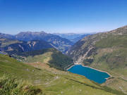
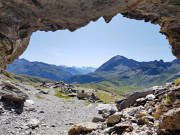
ASMB-VC011999
Vue sur le lac de la Gittaz et son barrage sur le tour du Rocher du Vent
©SavoieMontBlanc-Cervellin
- Fichier original HD - JPG (3024x4032px)
- Haute définition - JPG - JPG (4000x3000px)
- Haute définition © intégré - JPG - JPG (4000x3000px)
- Moyenne définition © intégré - JPG - JPG (1920x1440px)
- Moyenne définition - JPG - JPG (1920x1440px)
- Basse définition - JPG - JPG (1200x900px)
- Basse définition © intégré - JPG - JPG (1200x900px)
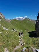
ASMB-VC012000
Randonneurs sur le tour du Rocher du Vent avec vue sur le massif du Maont-Blanc
©SavoieMontBlanc-Cervellin
- Fichier original HD - JPG (2592x1944px)
- Haute définition - JPG - JPG (2592x1944px)
- Haute définition © intégré - JPG - JPG (2592x1944px)
- Moyenne définition © intégré - JPG - JPG (1920x1440px)
- Moyenne définition - JPG - JPG (1920x1440px)
- Basse définition - JPG - JPG (1200x900px)
- Basse définition © intégré - JPG - JPG (1200x900px)
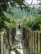
ASMB-LO08330
Randonneurs sur la passerelle du lac de la Rosière à Courchevel
©SavoieMontBlanc-Olkowicz
- Fichier original HD - JPG (2592x1944px)
- Haute définition - JPG - JPG (2592x1944px)
- Haute définition © intégré - JPG - JPG (2592x1944px)
- Moyenne définition © intégré - JPG - JPG (1920x1440px)
- Moyenne définition - JPG - JPG (1920x1440px)
- Basse définition - JPG - JPG (1200x900px)
- Basse définition © intégré - JPG - JPG (1200x900px)
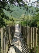
ASMB-LO08331
Randonneurs sur la passerelle du lac de la Rosière à Courchevel
©SavoieMontBlanc-Olkowicz
- Fichier original HD - JPG (6000x4000px)
- Haute définition - JPG - JPG (4000x2666px)
- Haute définition © intégré - JPG - JPG (4000x2666px)
- Moyenne définition © intégré - JPG - JPG (1920x1280px)
- Moyenne définition - JPG - JPG (1920x1280px)
- Basse définition - JPG - JPG (1200x800px)
- Basse définition © intégré - JPG - JPG (1200x800px)
ASMB-SB07555
Randonnée au lac de Peyre dans les Aravis
©SavoieMontBlanc-Bijasson
- Fichier original HD - JPG (2592x3456px)
- Haute définition - JPG - JPG (3456x2592px)
- Haute définition © intégré - JPG - JPG (3456x2592px)
- Moyenne définition © intégré - JPG - JPG (1920x1440px)
- Moyenne définition - JPG - JPG (1920x1440px)
- Basse définition - JPG - JPG (1200x900px)
- Basse définition © intégré - JPG - JPG (1200x900px)
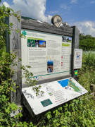
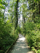
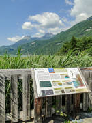
ASMB-EB07426
Panneau de signalisation de la réserve du Bout du lac d'Annecy à Doussard
©SavoieMontBlanc-Boutet
- Fichier original HD - JPG (2574x3432px)
- Haute définition - JPG - JPG (3432x2574px)
- Haute définition © intégré - JPG - JPG (3432x2574px)
- Moyenne définition © intégré - JPG - JPG (1920x1440px)
- Moyenne définition - JPG - JPG (1920x1440px)
- Basse définition - JPG - JPG (1200x900px)
- Basse définition © intégré - JPG - JPG (1200x900px)
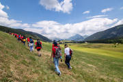
ASMB-EB07427
Randonneurs à la réserve du Bout du lac d'Annecy à Doussard
©SavoieMontBlanc-Boutet
- Fichier original HD - JPG (2592x3456px)
- Haute définition - JPG - JPG (3456x2592px)
- Haute définition © intégré - JPG - JPG (3456x2592px)
- Moyenne définition © intégré - JPG - JPG (1920x1440px)
- Moyenne définition - JPG - JPG (1920x1440px)
- Basse définition - JPG - JPG (1200x900px)
- Basse définition © intégré - JPG - JPG (1200x900px)
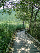
ASMB-EB07429
Réserve du Bout du lac d'Annecy à Doussard
©SavoieMontBlanc-Boutet
- Fichier original HD - JPG (2592x3456px)
- Haute définition - JPG - JPG (3456x2592px)
- Haute définition © intégré - JPG - JPG (3456x2592px)
- Moyenne définition © intégré - JPG - JPG (1920x1440px)
- Moyenne définition - JPG - JPG (1920x1440px)
- Basse définition - JPG - JPG (1200x900px)
- Basse définition © intégré - JPG - JPG (1200x900px)
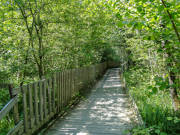
ASMB-EB07430
Réserve du Bout du lac d'Annecy à Doussard
©SavoieMontBlanc-Boutet
- Fichier original HD - JPG (2592x3456px)
- Haute définition - JPG - JPG (3456x2592px)
- Haute définition © intégré - JPG - JPG (3456x2592px)
- Moyenne définition © intégré - JPG - JPG (1920x1440px)
- Moyenne définition - JPG - JPG (1920x1440px)
- Basse définition - JPG - JPG (1200x900px)
- Basse définition © intégré - JPG - JPG (1200x900px)
ASMB-EB07431
Réserve du Bout du lac d'Annecy à Doussard
©SavoieMontBlanc-Boutet
- Fichier original HD - JPG (2592x3456px)
- Haute définition - JPG - JPG (3456x2592px)
- Haute définition © intégré - JPG - JPG (3456x2592px)
- Moyenne définition © intégré - JPG - JPG (1920x1440px)
- Moyenne définition - JPG - JPG (1920x1440px)
- Basse définition - JPG - JPG (1200x900px)
- Basse définition © intégré - JPG - JPG (1200x900px)
ASMB-EB07432
Réserve du Bout du lac d'Annecy à Doussard
©SavoieMontBlanc-Boutet
- Fichier original HD - JPG (2592x3456px)
- Haute définition - JPG - JPG (3456x2592px)
- Haute définition © intégré - JPG - JPG (3456x2592px)
- Moyenne définition © intégré - JPG - JPG (1920x1440px)
- Moyenne définition - JPG - JPG (1920x1440px)
- Basse définition - JPG - JPG (1200x900px)
- Basse définition © intégré - JPG - JPG (1200x900px)
ASMB-EB07433
Réserve du Bout du lac d'Annecy à Doussard
©SavoieMontBlanc-Boutet
- Fichier original HD - JPG (3456x2592px)
- Haute définition - JPG - JPG (3456x2592px)
- Haute définition © intégré - JPG - JPG (3456x2592px)
- Moyenne définition © intégré - JPG - JPG (1920x1440px)
- Moyenne définition - JPG - JPG (1920x1440px)
- Basse définition - JPG - JPG (1200x900px)
- Basse définition © intégré - JPG - JPG (1200x900px)
ASMB-EB07434
Réserve du Bout du lac d'Annecy à Doussard
©SavoieMontBlanc-Boutet
- Fichier original HD - JPG (3373x2530px)
- Haute définition - JPG - JPG (3373x2530px)
- Haute définition © intégré - JPG - JPG (3373x2530px)
- Moyenne définition © intégré - JPG - JPG (1920x1440px)
- Moyenne définition - JPG - JPG (1920x1440px)
- Basse définition - JPG - JPG (1200x900px)
- Basse définition © intégré - JPG - JPG (1200x900px)
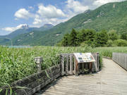
ASMB-EB07436
Panneau de signalisation de la réserve du Bout du lac d'Annecy à Doussard - vue sur les Dents de Lanfont
©SavoieMontBlanc-Boutet
- Fichier original HD - JPG (2494x3325px)
- Haute définition - JPG - JPG (3325x2494px)
- Haute définition © intégré - JPG - JPG (3325x2494px)
- Moyenne définition © intégré - JPG - JPG (1920x1440px)
- Moyenne définition - JPG - JPG (1920x1440px)
- Basse définition - JPG - JPG (1200x900px)
- Basse définition © intégré - JPG - JPG (1200x900px)
ASMB-EB07437
Panneau de signalisation de la réserve du Bout du lac d'Annecy à Doussard - vue sur les Dents de Lanfont
©SavoieMontBlanc-Boutet
- Fichier original HD - JPG (6000x4000px)
- Haute définition - JPG - JPG (4000x2666px)
- Haute définition © intégré - JPG - JPG (4000x2666px)
- Moyenne définition © intégré - JPG - JPG (1920x1280px)
- Moyenne définition - JPG - JPG (1920x1280px)
- Basse définition - JPG - JPG (1200x800px)
- Basse définition © intégré - JPG - JPG (1200x800px)
ASMB-SB07458
Randonnée au Plateau des Glières
©SavoieMontBlanc-Bijasson
- Fichier original HD - JPG (2581x3872px)
- Haute définition - JPG - JPG (3872x2581px)
- Haute définition © intégré - JPG - JPG (3872x2581px)
- Moyenne définition © intégré - JPG - JPG (1920x1279px)
- Moyenne définition - JPG - JPG (1920x1279px)
- Basse définition - JPG - JPG (1200x799px)
- Basse définition © intégré - JPG - JPG (1200x799px)
ASMB-SB04579
Randonneurs au col de la Colombière
©SavoieMontBlanc-Bijasson
- Fichier original HD - JPG (5436x3624px)
- Haute définition - JPG - JPG (4000x2666px)
- Haute définition © intégré - JPG - JPG (4000x2666px)
- Moyenne définition © intégré - JPG - JPG (1920x1280px)
- Moyenne définition - JPG - JPG (1920x1280px)
- Basse définition - JPG - JPG (1200x800px)
- Basse définition © intégré - JPG - JPG (1200x800px)
ASMB-SB0096
Randonnée en direction du bout du monde dans le Cirque du Fer à Cheval de la réserve naturelle de Sixt Fer à Cheval
©SavoieMontBlanc-Bijasson
- Fichier original HD - JPG (6000x4000px)
- Haute définition - JPG - JPG (4000x2666px)
- Haute définition © intégré - JPG - JPG (4000x2666px)
- Moyenne définition © intégré - JPG - JPG (1920x1280px)
- Moyenne définition - JPG - JPG (1920x1280px)
- Basse définition - JPG - JPG (1200x800px)
- Basse définition © intégré - JPG - JPG (1200x800px)
ASMB-SB0098
Randonnée en direction du bout du monde dans la réserve naturelle de Sixt Fer à Cheval
©SavoieMontBlanc-Bijasson
- Fichier original HD - JPG (2999x1999px)
- Haute définition - JPG - JPG (2999x1999px)
- Haute définition © intégré - JPG - JPG (2999x1999px)
- Moyenne définition © intégré - JPG - JPG (1920x1279px)
- Moyenne définition - JPG - JPG (1920x1279px)
- Basse définition - JPG - JPG (1200x799px)
- Basse définition © intégré - JPG - JPG (1200x799px)
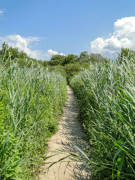
ASMB-SB0074
Randonnée en famille à l'étang de Crosagny
©SavoieMontBlanc-Bijasson
- Fichier original HD - JPG (3000x2000px)
- Haute définition - JPG - JPG (3000x2000px)
- Haute définition © intégré - JPG - JPG (3000x2000px)
- Moyenne définition © intégré - JPG - JPG (1920x1280px)
- Moyenne définition - JPG - JPG (1920x1280px)
- Basse définition - JPG - JPG (1200x800px)
- Basse définition © intégré - JPG - JPG (1200x800px)
ASMB-SB0071
Randonnée en famille près de l'étang de Crosagny
©SavoieMontBlanc-Bijasson
- Fichier original HD - JPG (2999x1999px)
- Haute définition - JPG - JPG (2999x1999px)
- Haute définition © intégré - JPG - JPG (2999x1999px)
- Moyenne définition © intégré - JPG - JPG (1920x1279px)
- Moyenne définition - JPG - JPG (1920x1279px)
- Basse définition - JPG - JPG (1200x799px)
- Basse définition © intégré - JPG - JPG (1200x799px)
ASMB-SB0069
Randonnée en famille près de l'étang de Crosagny
©SavoieMontBlanc-Bijasson
- Fichier original HD - JPG (2999x1999px)
- Haute définition - JPG - JPG (2999x1999px)
- Haute définition © intégré - JPG - JPG (2999x1999px)
- Moyenne définition © intégré - JPG - JPG (1920x1279px)
- Moyenne définition - JPG - JPG (1920x1279px)
- Basse définition - JPG - JPG (1200x799px)
- Basse définition © intégré - JPG - JPG (1200x799px)
ASMB-SB0068
Randonnée en famille près de l'étang de Crosagny
©SavoieMontBlanc-Bijasson
- Fichier original HD - JPG (2598x3811px)
- Haute définition - JPG - JPG (3811x2598px)
- Haute définition © intégré - JPG - JPG (3811x2598px)
- Moyenne définition © intégré - JPG - JPG (1920x1308px)
- Moyenne définition - JPG - JPG (1920x1308px)
- Basse définition - JPG - JPG (1200x818px)
- Basse définition © intégré - JPG - JPG (1200x818px)
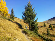
ASMB-SB0044
Randonnée en famille
©SavoieMontBlanc-Bijasson
- Fichier original HD - JPG (3898x2598px)
- Haute définition - JPG - JPG (3898x2598px)
- Haute définition © intégré - JPG - JPG (3898x2598px)
- Moyenne définition © intégré - JPG - JPG (1920x1279px)
- Moyenne définition - JPG - JPG (1920x1279px)
- Basse définition - JPG - JPG (1200x799px)
- Basse définition © intégré - JPG - JPG (1200x799px)
ASMB-SB0031
Alpage et lac des Confins - La Clusaz
©SavoieMontBlanc-Bijasson
- Fichier original HD - JPG (3898x2598px)
- Haute définition - JPG - JPG (3898x2598px)
- Haute définition © intégré - JPG - JPG (3898x2598px)
- Moyenne définition © intégré - JPG - JPG (1920x1279px)
- Moyenne définition - JPG - JPG (1920x1279px)
- Basse définition - JPG - JPG (1200x799px)
- Basse définition © intégré - JPG - JPG (1200x799px)
ASMB-SB0033
Lac des Confins - La Clusaz
©SavoieMontBlanc-Bijasson
- Fichier original HD - JPG (3264x1836px)
- Haute définition - JPG - JPG (3264x1836px)
- Haute définition © intégré - JPG - JPG (3264x1836px)
- Moyenne définition © intégré - JPG - JPG (1920x1080px)
- Moyenne définition - JPG - JPG (1920x1080px)
- Basse définition - JPG - JPG (1200x675px)
- Basse définition © intégré - JPG - JPG (1200x675px)
ASMB-CM0050
Descente du lac des Fées vers le lac de Saint-Guérin. Lac de Saint-Guérin en arrière-plan
©SavoieMontBlanc-Mari
- Fichier original HD - JPG (3425x1927px)
- Haute définition - JPG - JPG (3425x1927px)
- Haute définition © intégré - JPG - JPG (3425x1927px)
- Moyenne définition © intégré - JPG - JPG (1920x1080px)
- Moyenne définition - JPG - JPG (1920x1080px)
- Basse définition - JPG - JPG (1200x675px)
- Basse définition © intégré - JPG - JPG (1200x675px)
ASMB-CM0051
Sentier longeant la route du Cormet d?Arêches, en direction du lac de Saint-Guérin
©SavoieMontBlanc-Mari
- Fichier original HD - JPG (2569x3425px)
- Haute définition - JPG - JPG (3425x2569px)
- Haute définition © intégré - JPG - JPG (3425x2569px)
- Moyenne définition © intégré - JPG - JPG (1920x1440px)
- Moyenne définition - JPG - JPG (1920x1440px)
- Basse définition - JPG - JPG (1200x900px)
- Basse définition © intégré - JPG - JPG (1200x900px)
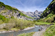
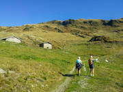
ASMB-VC0019
Randonnée en direction du refuge du Mont-Pourri dans le Parc national de la Vanoise
©SavoieMontBlanc-Cervellin
- Fichier original HD - JPG (3425x2569px)
- Haute définition - JPG - JPG (3425x2569px)
- Haute définition © intégré - JPG - JPG (3425x2569px)
- Moyenne définition © intégré - JPG - JPG (1920x1440px)
- Moyenne définition - JPG - JPG (1920x1440px)
- Basse définition - JPG - JPG (1200x900px)
- Basse définition © intégré - JPG - JPG (1200x900px)
ASMB-VC0020
Randonnée en direction du refuge du Mont-Pourri dans le Parc national de la Vanoise
©SavoieMontBlanc-Cervellin
- Fichier original HD - JPG (3425x2569px)
- Haute définition - JPG - JPG (3425x2569px)
- Haute définition © intégré - JPG - JPG (3425x2569px)
- Moyenne définition © intégré - JPG - JPG (1920x1440px)
- Moyenne définition - JPG - JPG (1920x1440px)
- Basse définition - JPG - JPG (1200x900px)
- Basse définition © intégré - JPG - JPG (1200x900px)
ASMB-VC0021
Randonnée en direction du refuge du Mont-Pourri dans le Parc national de la Vanoise
©SavoieMontBlanc-Cervellin
- Fichier original HD - JPG (3425x2569px)
- Haute définition - JPG - JPG (3425x2569px)
- Haute définition © intégré - JPG - JPG (3425x2569px)
- Moyenne définition © intégré - JPG - JPG (1920x1440px)
- Moyenne définition - JPG - JPG (1920x1440px)
- Basse définition - JPG - JPG (1200x900px)
- Basse définition © intégré - JPG - JPG (1200x900px)
ASMB-VC0022
Randonnée en direction du refuge du Mont-Pourri dans le Parc national de la Vanoise
©SavoieMontBlanc-Cervellin
- Fichier original HD - JPG (3425x2569px)
- Haute définition - JPG - JPG (3425x2569px)
- Haute définition © intégré - JPG - JPG (3425x2569px)
- Moyenne définition © intégré - JPG - JPG (1920x1440px)
- Moyenne définition - JPG - JPG (1920x1440px)
- Basse définition - JPG - JPG (1200x900px)
- Basse définition © intégré - JPG - JPG (1200x900px)
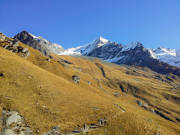
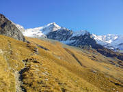
ASMB-VC0025
Randonnée en direction du col de la Bathie
©SavoieMontBlanc-Cervellin
- Fichier original HD - JPG (3425x2569px)
- Haute définition - JPG - JPG (3425x2569px)
- Haute définition © intégré - JPG - JPG (3425x2569px)
- Moyenne définition © intégré - JPG - JPG (1920x1440px)
- Moyenne définition - JPG - JPG (1920x1440px)
- Basse définition - JPG - JPG (1200x900px)
- Basse définition © intégré - JPG - JPG (1200x900px)
ASMB-VC0026
Randonnée en direction du Mirantin dans le Beaufortain
©SavoieMontBlanc-Cervellin
- Fichier original HD - JPG (2569x3425px)
- Haute définition - JPG - JPG (3425x2569px)
- Haute définition © intégré - JPG - JPG (3425x2569px)
- Moyenne définition © intégré - JPG - JPG (1920x1440px)
- Moyenne définition - JPG - JPG (1920x1440px)
- Basse définition - JPG - JPG (1200x900px)
- Basse définition © intégré - JPG - JPG (1200x900px)
ASMB-VC0027
Randonnée en direction du Mirantin dans le Beaufortain
©SavoieMontBlanc-Cervellin
- Fichier original HD - JPG (3264x1836px)
- Haute définition - JPG - JPG (3264x1836px)
- Haute définition © intégré - JPG - JPG (3264x1836px)
- Moyenne définition © intégré - JPG - JPG (1920x1080px)
- Moyenne définition - JPG - JPG (1920x1080px)
- Basse définition - JPG - JPG (1200x675px)
- Basse définition © intégré - JPG - JPG (1200x675px)
ASMB-CM0035
Randonneurs et vttistes sur le GR55 en direction du col de Chavière et du refuge de Péclet-Polset - Au fond glacier de Gébroulaz - Pralognan
©SavoieMontBlanc-Mari
- Fichier original HD - JPG (2989x1759px)
- Haute définition - JPG - JPG (2989x1759px)
- Haute définition © intégré - JPG - JPG (2989x1759px)
- Moyenne définition © intégré - JPG - JPG (1920x1129px)
- Moyenne définition - JPG - JPG (1920x1129px)
- Basse définition - JPG - JPG (1200x706px)
- Basse définition © intégré - JPG - JPG (1200x706px)
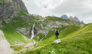
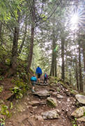
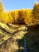
ASMB-CM0034
Cascade sur le sentier du lac des vaches et du col de la Vanoise - Pralognan
©SavoieMontBlanc-Mari
- Fichier original HD - JPG (2592x1944px)
- Haute définition - JPG - JPG (2592x1944px)
- Haute définition © intégré - JPG - JPG (2592x1944px)
- Moyenne définition © intégré - JPG - JPG (1920x1440px)
- Moyenne définition - JPG - JPG (1920x1440px)
- Basse définition - JPG - JPG (1200x900px)
- Basse définition © intégré - JPG - JPG (1200x900px)
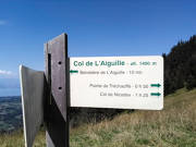
ASMB-ALH0017
Panneau de signalisation randonnée dans le géoparc Chablais
©SavoieMontBlanc-Hossel
- Fichier original HD - JPG (4016x2451px)
- Haute définition - JPG - JPG (4000x2441px)
- Haute définition © intégré - JPG - JPG (4000x2441px)
- Moyenne définition © intégré - JPG - JPG (1920x1171px)
- Moyenne définition - JPG - JPG (1920x1171px)
- Basse définition - JPG - JPG (1200x732px)
- Basse définition © intégré - JPG - JPG (1200x732px)
ASMB-SB0007
Pique-nique à la Clef des Annes avec vue sur le Grand-Bornand et le Jalouvre à droite
©SavoieMontBlanc-Bijasson
- Fichier original HD - JPG (4044x2480px)
- Haute définition - JPG - JPG (4000x2453px)
- Haute définition © intégré - JPG - JPG (4000x2453px)
- Moyenne définition © intégré - JPG - JPG (1920x1177px)
- Moyenne définition - JPG - JPG (1920x1177px)
- Basse définition - JPG - JPG (1200x735px)
- Basse définition © intégré - JPG - JPG (1200x735px)
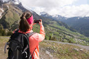
ASMB-SB0011
Randonneurs au dessus du Grand-Bornand avec vue sur le Jalouvre à droite
©SavoieMontBlanc-Bijasson
- Fichier original HD - JPG (4016x2419px)
- Haute définition - JPG - JPG (4000x2409px)
- Haute définition © intégré - JPG - JPG (4000x2409px)
- Moyenne définition © intégré - JPG - JPG (1920x1156px)
- Moyenne définition - JPG - JPG (1920x1156px)
- Basse définition - JPG - JPG (1200x722px)
- Basse définition © intégré - JPG - JPG (1200x722px)
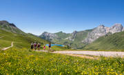
ASMB-SB0008
Randonneurs à la Clef des Annes avec vue sur le Mont-Lachat, le Grand-Bornand et le Jalouvre à droite
©SavoieMontBlanc-Bijasson
- Fichier original HD - JPG (2738x1825px)
- Haute définition - JPG - JPG (2738x1825px)
- Haute définition © intégré - JPG - JPG (2738x1825px)
- Moyenne définition © intégré - JPG - JPG (1920x1279px)
- Moyenne définition - JPG - JPG (1920x1279px)
- Basse définition - JPG - JPG (1200x799px)
- Basse définition © intégré - JPG - JPG (1200x799px)
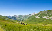
ASMB-SC0473
Randonnée sur la Route de la Soif au dessus du village de la Giettaz-en-Aravis
©SavoieMontBlanc-Chabance
- Fichier original HD - JPG (2738x1825px)
- Haute définition - JPG - JPG (2738x1825px)
- Haute définition © intégré - JPG - JPG (2738x1825px)
- Moyenne définition © intégré - JPG - JPG (1920x1279px)
- Moyenne définition - JPG - JPG (1920x1279px)
- Basse définition - JPG - JPG (1200x799px)
- Basse définition © intégré - JPG - JPG (1200x799px)
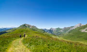
ASMB-SC0472
Randonnée sur la Route de la Soif au dessus du village de la Giettaz-en-Aravis
©SavoieMontBlanc-Chabance